Lake Huron Nature Preserve Recap
 Jonathan tweeted this week about our visits to two nature preserves along Lake Huron in Northern Michigan. I know that at least one person wants more details, so here they are:
The John Arthur Woollam Preserve
(This official website for the preserve includes directions at the bottom.)
We took a drive around the Cedarville, Michigan area on M134. About six miles outside of Cedarville, I saw a new-looking sign for the preserve that I didn’t remember from prior trips on this highway. (I found out shortly that this sign is about a year old, because this preserve opened fairly recently.) We decided to stop and check it out; however, we had already passed the turn-off when we decided this, so we had to drive a bit further down the road and find a place to turn around. Right after we passed the sign for the preserve (and couldn’t make the turn in time), we passed two signs for the “Cedar Campus,” so keep an eye out for these signs if you don’t see the sign for the preserve. If you are coming from Cedarville, all of these signs will be on your right.
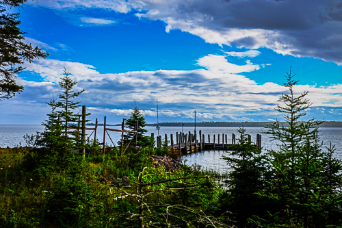
The official website explains the preserve in a fantastic way. Let me just say that Jonathan and I had a fun walk through the woods. The main trail that we took ends at an aging boat dock on the shore of Lake Huron. (See the photo at the top of this blog entry.)
De Tour Peninsula Nature Preserve
This link from the “Pure Michigan” website is the closest thing that I could find to an official website. You will find the directions here.
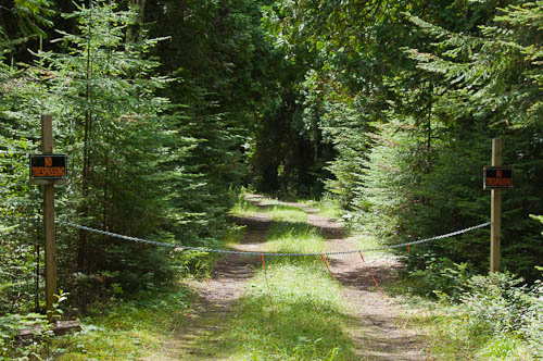
Our attempts to see the De Tour Reef Light this week ended with the two “No Trespassing” signs depicted at the bottom of this blog post. This outcome was much different than our previous visit here.
This lighthouse is one mile offshore between DeTour Villiage and Drummond Island. Several years ago, Jonathan read that we could see the lighthouse if we accessed the shore on DeTour Point by hiking to the end of the main trail in this nature preserve. The main trail is actually a dirt road closed to traffic. This trail did take us out onto the DeTour Peninsula, surrounded on both sides by forest. We walked past a clearing in the trees where we saw the lake shore on our left. A few hundred yards later, we heard but didn’t see the lake on our right. Then we reached the end of the trail-road.
We came to a large unoccupied house surrounded by a yard. We called out several times to see if anybody else was around, and received no answer. Since we saw no signed posted that would indicate that we shouldn’t be there, we crossed the yard in front of this house to reach the shore of Lake Huron at DeTour Point. We did actually see the lighthouse from this beach. We took photos, but since we made the walk on a cloudy and rainy day, Jonathan hoped to get better photos under a clearer sky.
This week we returned to the preserve, hoping to get our nicer lighthouse photos. However, at the end of the trail we found a chain across the road and the above-mentioned “No Treaspassing” signs. So no lighthouse viewing.
We have so many questions about this nature preserve that we haven’t been able to find online. If anybody knows the backstory, please comment.
Here are my previous blog entries about Northern Michigan:
Somewhere in Time (How to Really Time Travel)
7 Quirky Tips for Mackinac Island
5 Ways That Mackinac Island Reminds Me of Home
Sault Ste. Marie Adventure, 2014
Here is Jonathan’s previous blog entry about Northern Michigan:
The Final Stop for the S/V Peacemaker?